
The top photograph shows several features common in the Chihuahuan Desert. The photograph was taken from the bolson floor.
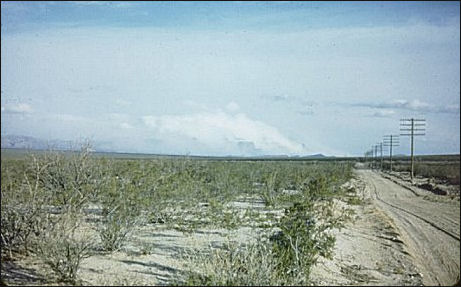
Tularosa Basin looking north toward the Oscura Mountains (largely obscured by clouds formed as the east wind is lifted by the mountains). Vegetation is almost pure creosotebush desert scrub. Photo by Arthur H. Harris, early 1950s.
These bolsons, or basins, generally are structurally deep depressions partially filled with sediments from the surrounding highlands. In most cases, the bolsons are formed by down-faulted blocks, while up-lifted or tilted blocks on either side separate the basins from one another. In much of the Chihuahuan Desert region, these basins and ranges trend in a general north-south or northwest-southeast direction. Less prominent structural highs tend to delimit the northern and southern ends of the bolsons. (Volcanism also has been prominent in mountain building, however, resulting in mountains that look quite different—also see the reference to the Organ Mountains below.)
Hemmed in on all sides by highlands, drainage generally is internal,
with playas (so-called "dry lakes" which usually hold water only seasonally)
located in the lowest portions of the basins. Exceptions to this drainage pattern are
where rivers originating 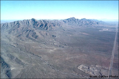 in highland areas, usually outside of
the desert region, have filled basins with sediments to the point where overflow
occurred at the lowest margin, eventually uniting series of basins by a through-flowing
river. The Rio Grande is an excellent example of
this, originating in the high mountains of Colorado and New Mexico and flowing south
and southeast through formerly separate, close-drainage basins.
in highland areas, usually outside of
the desert region, have filled basins with sediments to the point where overflow
occurred at the lowest margin, eventually uniting series of basins by a through-flowing
river. The Rio Grande is an excellent example of
this, originating in the high mountains of Colorado and New Mexico and flowing south
and southeast through formerly separate, close-drainage basins.
East side of the Franklin Mountains, El Paso County, Texas. The area pictured has been protected from development by virtue of a past in which it was an Army firing range; unexploded ordnance renders the area dangerous and too costly thus far to clear. Photograph by Scott M. Cutler, 9 March 1998.
Separating the basins, fault-block mountain ranges generally trend more or less north-south north of the Rio Grande and northwest-southeast farther south. The Franklin Mountains, shown in the photograph, is a rather typical medium-sized desert range. Despite the barren appearance, canyons and other protected areas harbor a great diversity of animals and plants.
Other views of such ranges may help visualization.
The desert mountains greatly increase the biological diversity of the Chihuahuan Desert Region, providing both macro- and microclimatic conditions different than found on the desert floor. In general, increasing elevation results in cooler temperatures and greater effective moisture, and topographic relief provides a number of habitats unavailable in the flatlands. South-facing and west-facing slopes tend to be relatively hot and dry compared to those facing east or north, for example.
The higher mountain ranges within or bounding the desert often support woodland and forest, and are separated from other such plant communities by surrounding grassland or desert. The Animas Mountains of extreme southwestern New Mexico are a good example of what popularly are called Sky Islands.