
The Chihuahuan Desert is the easternmost and southernmost of the four North American deserts: the Great Basin Desert, the Sonoran Desert, the Mojave Desert, and the Chihuahuan Desert.
Although a desert might be conceptualized as an island of aridity surrounded by better watered lands, deserts—unlike real islands—do not have distinct boundaries for all to see. As a result, different concepts have arisen through time as to what defines the Chihuahuan Desert and its boundaries. The delineation used for the site logo is that of Schmidt (1979), based on the de Martonne Index of Aridity (de Martonne 1927). Some different concepts that have appeared in the literature are shown in the Many Chihuahuan Deserts pages. There also is available a general discussion of factors involved in defining deserts and the Chihuahuan Desert in particular.
One more caveat regarding the Chihuahuan Desert: This site covers the Chihuahuan Desert Region, including not only the desert itself, but also the highland "islands" surrounded by desert and, to a degree, bordering montane areas that are isolated by surrounding, non-forested lowlands.
In Mexico, the Chihuahuan Desert lies within the Central Plateau, bounded on the west by the Sierra Madre Occidental and on the east by the Sierra Madre Oriental, with its southern boundary in Zacatecas. The desert's northern portion extends into southeastern Arizona, southern New Mexico, and Trans-Pecos Texas.
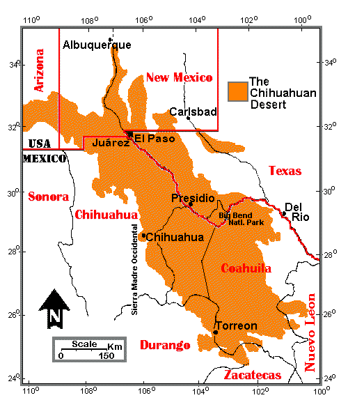
After an original map by R. Schmidt (1979). The Chihuahuan Desert Pages also use the outline of this map as a logo.
Because of its position in the interior of the continent and its relatively high elevation, ranging from about 600 m to around 1675 m (about 1970 to 5500 ft), this desert tends to have hot summers and cool to cold winters. All areas are subject to occasional winter frosts, and northern portions regularly receive hard freezes. Cold-sensitive plants occur throughout the low elevations of the Bolson de Mapimí and the Big Bend region; as elevation and latitude increase, such species become fewer in number and eventually disappear.
Unlike the Sonoran Desert, where large cacti and small trees are prominent in many areas, the Chihuahuan Desert is predominantly a shrub desert. Creosotebush (Larrea tridentata) is nearly ubiquitous. Tarbush (Flourensia cernua), an indicator species for the Chihuahuan Desert, is more scattered, but may form extensive stands under proper soil and moisture conditions. Other common plants in the northern portions include such shrubs as Four-winged Saltbush (Atriplex canescens), Mariola (Parthenium incanum), and Honey Mesquite (Prosopis glandulosa); succulents such as a variety of small to medium-sized cacti, yuccas (Yucca elata, Yucca torreyi), and agaves (including Agave lechuguilla, also often considered an indicator plant of the Chihuahuan Desert). Various grasses occur commonly, including Black Grama (Bouteloua eriopoda) and Tobosa Grass (Hilaria mutica). Other plants include Ocotillo (Fouquieria spendens), Sotol (Dasylirion spp.), and the Barrel Cactus (Ferocactus wislizenii).
The Chihuahuan Desert is rich in animal life. Some typical animals, many of which also occur outside of the desert region, include the Desert Cottontail (Sylvilagus audubonii), Black-tailed Jack Rabbit (Lepus californicus), Cactus Mouse (Peromyscus eremicus), Kit Fox (Vulpes macrotis), Cactus Wren (Campylorhynchos brunneicapillus), Greater Roadrunner (Geococcyx californianus), Mojave Rattlesnake (Crotalus scutulatus), Coachwhip snake (Masticophis flagellum), New Mexican Whiptail lizard (Aspidoscelis neomexicanus), Red-spotted Toad (Anaxyrus punctatus), and Barred Tiger Salamander (Ambystoma mavortium).
Some of these plants and animals, along with other organisms of the Chihuahuan Desert, may be seen in the parts of this site focusing on the biology of the region. The combined Chihuahuan Desert Gardens and Plants pages also have images of many of the regional plants, along with information about the plants; the pages are searchable by scientific or common names and by keywords.
A prominent feature of the Chihuahuan Desert is the occurrence  of mountain ranges, separated by valleys (bolsons) throughout the region. The
Franklin Mountains, which bisect the northern Chihuahuan Desert city of El Paso, is a
typical medium-sized range. Desert mountains range from slight prominences to soaring
highlands. Regardless, such ranges provide habitats absent on the flatlands and add new
species to the regional biota. The higher mountains often are described as biotic
islands, since the upper elevations are inhabited by organisms typical of more northern
regions, but isolated from the northern populations by the surrounding desert
lowlands.
of mountain ranges, separated by valleys (bolsons) throughout the region. The
Franklin Mountains, which bisect the northern Chihuahuan Desert city of El Paso, is a
typical medium-sized range. Desert mountains range from slight prominences to soaring
highlands. Regardless, such ranges provide habitats absent on the flatlands and add new
species to the regional biota. The higher mountains often are described as biotic
islands, since the upper elevations are inhabited by organisms typical of more northern
regions, but isolated from the northern populations by the surrounding desert
lowlands.
The Natural History of the Chihuahuan Desert is a short course to introduce people interested in learning about the desert in greater depth than given here.
E-mail: aharris@utep.edu