The El Paso area of the Chihuahuan Desert shows signs of much recent volcanic activity, some of it quite violent. As recent as 500 years ago, there were volcanic eruptions just north of here in New Mexico. Most of the activity in our immediate area is considerably older than that, however.
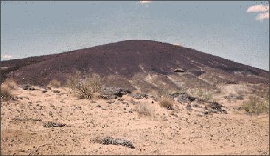
Just west of El Paso lies the Potrillo Volcanic Field. This field includes hundreds of cinder cones (much like the one shown in the photo below), lava flows, maars, and ash flows.
Black lava rose from depths as deep as 50 miles, at temperatures of about 2,000° F. As the lava met the ground water in the old river sediments, it explosively changed the water to steam. The lava exploded into fine ash and cinders. Later, the lava emerged as quiet flows which moved down hill as a dense liquid. The lava flows engulfed trees, filled depressions, and formed a type of igneous rock named basalt.

A cinder cone in the Potrillo Volcanic Field, just west of El Paso.
UTEP Department of Geology
In several places, the lava produced so much explosive steam as it boiled the ground water that great volumes of the old river sediment were blown out around the vent with little cinder or ash accumulating. The violent eruption excavated a broad, funnel-shaped hole about a mile wide. Most of the material that was blown out fell back so that the hole is now only a few hundred feet deep. The result was the formation of a broad, shallow depression called a maar, pronounced mar. Several of these maars lie east of the Potrillo Volcanic Field. Kilbourne's Hole and Hunt's Hole, named for early ranchers in the region, are the best known. To see these two maars CLICK HERE.
Now click on the NEXT button and let's begin to learn about Earthquakes.
If you are on the Internet, click on the image below to learn more about volcanoes and earthquakes.

 NEXT
NEXT