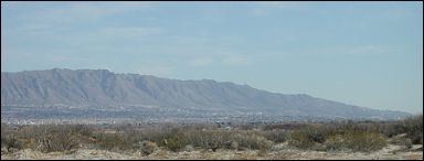

Did you know that, years and years ago, some unknown person moved the Rocky Mountains to El Paso? Well, not literally moved them, of course, but apparently successfully persuaded numerous El Pasoans that our own Franklin Mountains marked the southern terminus of the Rockies. In fact, persuaded so successfully, that this claim has repeatedly appeared in print, thereby assuming the status of truth to the ordinary bear.
Most geologists, however, would place the nearest approach of the Rockies almost a whole state away, in northern New Mexico, where the Sangre de Cristo Mountains loom over Santa Fe. Instead of being part of the Rocky Mountain Geologic Province, the northern Chihuahuan Desert lies within Basin and Range country. Indeed, the deserts of the United States lie almost entirely in this province, from the Great Basin and Mojave deserts in the north to the more southerly Chihuahuan and Sonoran.
Someone should have informed the long-ago miscreant that our mountains
are nothing to be ashamed of—that far from being inferior to the Rocky Mountains,
they're just different.

Contributor: Arthur H. Harris, Laboratory for Environmental Biology, Centennial Museum, University of Texas at El Paso.
Desert Diary is a joint production of the Centennial Museum and KTEP National Public Radio at the University of Texas at El Paso.

The southern tip of the Rocky Mountains according to the El Paso myth. View from the west of the southern portion of the Franklin Mountains. Photograph by A.H. Harris.
Shimer, J. A. 1972. Field guide to landforms in the United States.
Macmillan Co., New York. 272 pp. ![]()