

Its generally agreed that we live in the Chihuahuan Desert, though a few holdouts consider us to be semiarid rather than desert. Nevertheless, Chihuahuan Desert it is! There is, though, a minor problem. We don't seem to agree on what's Chihuahuan Desert and what's not. The Centennial Museum's website shows more than a dozen different concepts of the desert, some quite similar to each other, some very different. The basic difficulty comes down to, "How do we define a desert?" A combination of precipitation and temperature or potential evaporation often is used, but not everyone agrees on how much precipitation and what temperatures. Others turn to the plants and try to define the desert by the distribution of, say, creosotebush or tarbush or lechuguilla.
Luckily, most of the arguments focus on determining the boundaries of
the desert, and places like El Paso and Big Bend are far enough from the edges to be
safely considered desert regardless of definition. But pity our New Mexican neighbors,
doomed to uncertainty; in a manner of speaking, forever living on the edge.
Contributor: Arthur H. Harris, Laboratory for Environmental Biology, Centennial Museum, University of Texas at El Paso.
Desert Diary is a joint production of the Centennial Museum and KTEP National Public Radio at the University of Texas at El Paso.
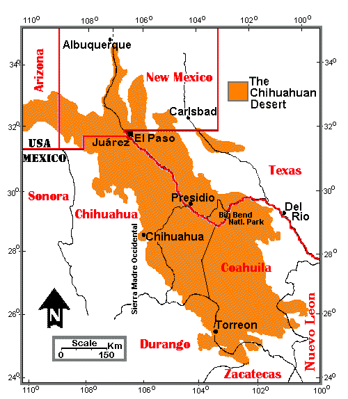
The Chihuahuan Desert, after an original map by R. Schmidt (1979). The Chihuahuan Desert Pages also use the outline of this map as a logo.
Ackerman, E. A. 1941. The Köppen classification of climates in North America. Geographical Review 31:105-111.
de Martonne, E. 1927. Regions of interior basin drainage. Geographical Review 17:397-414.
Flores Mata, G., et al. 1971. Mapa y descripcion de los tipos de vegetacion de la Republica Mexicana. Secretaria de Recursos Hidraulicos, 59 pp + 1 map, scale 1:2 mil. México.
Henrickson, J., and J. Garcia. 1976. Maps of the Chihuahuan Desert Region. California State University, Los Angeles. 49 pp.
Henrickson, J., and R. M. Straw. 1976. A gazetteer of the Chihuahuan Desert Region. California State University, Los Angeles. 273 pp.
Instituto de GeografÃa. 1970. Carta de climas de la republica. Univ. Autónoma de México, Comisión de estudios del Territorio Nacional. Scale 1:500,000. México.